Detailed understanding of local traffic conditions through diverse and detailed monitoring systems
In order for citizens to avoid traffic congestion and make their movements smoother, and to determine whether their movements are beneficial to the community and the environment, it is necessary to grasp the actual traffic conditions in the community in a detailed and easy-to-understand manner, and to improve the accuracy of movement and traffic information.
In the past, with the development of ICT, road congestion and public transportation services such as buses and railroads have been monitored, and some of this information has been provided to people as services. However, sensors to monitor road congestion have been installed mainly on arterial roads, making it difficult to monitor congestion on roads other than arterial roads.
On the other hand, there are sensors in cities for various purposes other than monitoring road congestion, such as surveillance cameras. Efficient use of these sensors will enable a more detailed understanding of the actual traffic conditions on more roads.
Kashiwa ITS Smart City has established a system that enables the aggregation of information collected by various entities and the continuous monitoring of traffic conditions using advanced technology based on the aggregated information. This enables a more detailed and integrated understanding of the actual traffic conditions of areas and routes that could not be grasped in the past.
ITS Spot Services in the Kashiwa Area -Acquiring Actual Traffic Data Using ITS Spots
Outline of ITS Spot Service
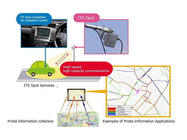
ITS Spot Service is a next-generation road-vehicle cooperative system promoted by Japan, which provides wide-area road traffic information and collects probe data through high-speed, large-capacity communications using 5.8 GHz narrowband communications between ITS Spot roadside units installed on roads and ITS Spot compatible on-board equipment. Since 2011, 1,600 ITS Spot stations have been installed and are providing this service mainly on expressways nationwide.
The ITS Spot service has the following information-gathering and information-providing functions.
1.Information Gathering Function
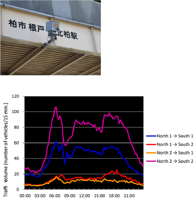
The ITS Spot on-board unit can store the most recent 80 km of driving history and uplink the stored probe information when the vehicle passes under the ITS Spot roadside unit. The ability to collect data continuously 24 hours a day, 365 days a year makes it possible to grasp not only the actual traffic conditions by time of day, but also by day of the week, month, and season, as well as the actual traffic conditions in the event of major disruptions. It will also be possible to grasp the actual state of traffic in the event of a major disruption. Therefore, it is possible to collect basic data that contributes to a detailed understanding of actual traffic conditions and to the consideration of road management and traffic countermeasures accordingly.
2. Information Provision Function
The information provision function provides road traffic information and safe driving support information on the car navigation system in graphic, image, and audio formats. By using this function, information can be provided directly and effectively to road users while driving. By providing appropriate information to road users, it is possible to encourage them to select the best route and avoid traffic congestion, as well as to avoid dangerous events, thereby contributing to improving traffic congestion and reducing traffic accidents.
■Information collection and provision scheme using ITS spots
Outline of ITS Spot Service
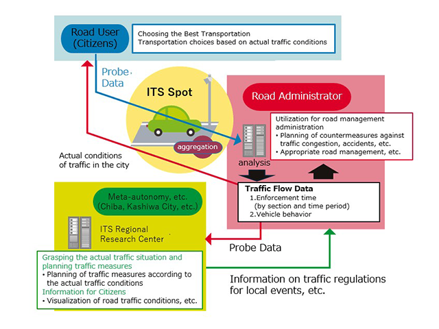
ITS spots, which are currently being developed mainly on expressways in the Kashiwa area, will be developed in the urban center to efficiently collect probe information from vehicles traveling in the urban center and to efficiently grasp the actual traffic conditions in the urban area. The collected probe information will be shared with local governments and traffic managers, aiming for road traffic management more suited to the actual conditions of the region.
In addition, we are considering using the information provision function of ITS spots to provide road users with information that compares the routes they have used with the optimal routes, recommends routes to use next time, and provides information on parking lot selection according to the actual availability of parking lots. In the future, the project aims to optimize traffic flow and parking lot usage in the central Kashiwa area.
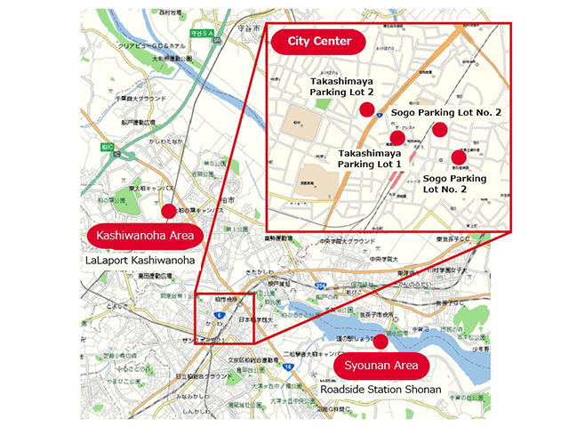
ITS spots to be installed
There are six ITS spots in the Kashiwa area: four in the central city area, one in the Kashiwanoha area, and one in the Numan area.
- Central City Area
- Kashiwa Takashimaya Station Mall Parking Lots 1 and 2, Sogo Kashiwa Store Parking Lots 1 and 2
- Kashiwanoha Area
- LaLaport Kashiwanoha Parking Lot
- Shonan Area
- Roadside Station Shonan
■ITS spots in the Kashiwa area
Traffic Information Monitoring -Improving Existing Cameras into Image Sensors Using Spatio-Temporal MRF and Understanding Traffic Conditions Using License Plate Sensors
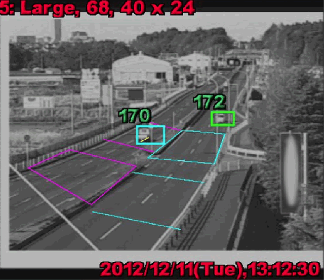
Currently, various surveillance cameras are installed on roadsides and streets, but they are usually only used for monitoring and the images obtained from them are not utilized as data. The image sensor system for existing cameras using space-time MRF is a low-cost system for collecting basic traffic data such as traffic volume and speed from live camera images, which are not used for anything other than monitoring roads and traffic.
In the Kashiwa area, for the purpose of collecting traffic data for nowcast simulation, images from a live camera installed on National Route 6 were collected through an Internet connection and processed using a space-time MRF model to obtain pulse data (two vehicle types classification and point speed) for each vehicle, 5-minute pitch The system is being operated on a trial basis.
The license plate sensor system transfers license plate information obtained from license plate readers (Oc-i) to the database server via communication, and matches the data to determine traffic conditions (travel speed between points, etc.) in the network in real time.
In addition, by taking advantage of the characteristics of license plate information, the system can determine vehicle registration by OD and vehicle type, and by combining it with vehicle type classification (business category: private cars, commercial vehicles), it can determine rough usage characteristics such as business, daily life, and logistics.
In the Kashiwa area, temporary license plate readers were installed on National Routes 6 and 16 around the Yobuzuka intersection, a major traffic congestion point in the area, to collect traffic data for nowcasting simulations. The traffic volume (daily and hourly), traffic characteristics (OD traffic volume), travel time by time zone, and other basic traffic data are collected at the installation points.